三.都市發展
金邊市面積375km2,約台北市1.4倍,都市面積不大,由市中心往東西南北邊,騎摩托車約半小時均可到達,坐嘟嘟車約4、5美元。上下班時間機車、汽車、嘟嘟車臃擠,首都塞車問題嚴重。
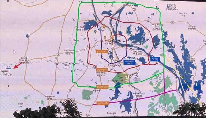
【都市發展】:依照都市發展先後順序、由內核心往外圍擴大,「一環圈」發展擴大到「二環圈」、「三環圈」。
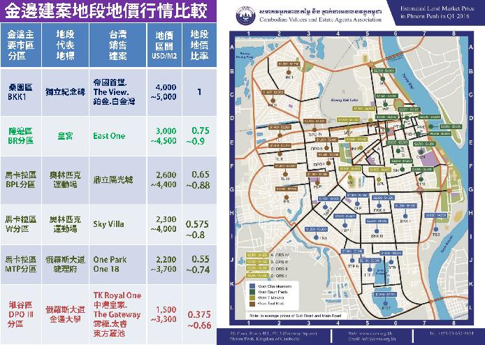
「一環圈」:金邊市舊城區域,西哈努克、尼赫魯、俄羅斯、莫尼旺大道以內區域,行政區包括東邊的「隆邊區」(代表地標:皇宮、中央市場)、西邊的「馬卡拉區」(代表地標:奧林匹克運動場)。
「二環圈」:毛澤東、俄羅斯大道以內區域。行政區包括南邊地價最高的「桑園區」(代表地標:獨立紀念碑)、東北邊的「隆邊區」、西邊的「馬卡拉區」、毛澤東大道以東堆谷區。
「三環圈」:金邊機場以東、271路以北、598路以東、273、70、72路以南區域,金邊市區最大範圍。(代表地標:金邊大學)。以外則為郊區。行政區包括金邊市主要的4個行政區:桑園區、隆邊區、馬卡拉區、堆谷區。
【都市計畫】因應外來人口日益增加,解決首都住宅土地空間不足、交通臃擠塞車、環境衛生等問題,大金邊市都市計畫將擴大30公里,城區面積倍增至675km2,人口倍增至500萬人。行政區將擴大為14個行政區。
附錄地圖:
1.google金邊地圖(內有行政區域、政府機關、商業設施、觀光景點、地標、建築物標的)
2.金邊地圖(一、二、三環圈)
3. Urban Development
Phnom Penh covers an area of 375km2, which is about 1.4 times that of Taipei City. The urban area is not large. From the city center to the east, west, south, north, it takes about half an hour to get there by motorcycle, and it costs about US$4 or US$5 by tuk-tuk. During commuting hours, locomotives, cars, and tuk-tuks are overcrowded, and the traffic jam problem in the capital is serious.
[Urban Development]: According to the sequence of urban development, expand from the inner core to the outer periphery, and expand the development of the "first ring" to the "second ring" and "third ring".
"One Ring": the old city area of Phnom Penh, the area within Sihanoukville, Nehru, Russia, and Monivong Avenue, the administrative area includes the "Dongbian District" in the east (representative landmarks: Royal Palace, Central Market), and the "Dongbian District" in the west. Makala District" (representative landmark: Olympic Stadium).
"Second Ring Circle": The area within Mao Zedong and Russia Boulevards. The administrative districts include "Sangyuan District" with the highest land price in the south (representative landmark: Independence Monument), "Dunbian District" in the northeast, "Makala District" in the west, and Toul Kork District east of Mao Zedong Avenue.
"Three Rings": East of Phnom Penh Airport, north of Road 271, east of Road 598, south of Roads 273, 70, and 72, the largest area in Phnom Penh City. (Representative Landmark: University of Phnom Penh). The rest are suburbs. The administrative district includes four main administrative districts in Phnom Penh: Sangyuan District, Daunbian District, Makala District, and Toul Kork District.
[Urban plan] In response to the increasing number of migrants and solving problems such as insufficient housing land space, traffic congestion, and environmental sanitation in the capital, the urban plan of Greater Phnom Penh City will be expanded by 30 kilometers, the urban area will double to 675km2, and the population will double to 5 million. people. The administrative district will be expanded to 14 administrative districts.
Appendix map:
1.Google Phnom Penh map (includes administrative areas, government agencies, commercial facilities, sightseeing spots, landmarks, buildings)
2. Map of Phnom Penh (first, second and third rings) |
 .......热点省份代理人 詹经理 Rock Chan